DOLOMITES TREKKING

Day 1 :

Meeting at Forno di Zoldo (840m) - Transfer to Paso Duran (1601m) – Time to start the hike to Rifugio Bruto Carestiato (1834m) right next the south face of the Moiazza.

Duration : 30 '


Day 2 :

Rifugio Carestiato - Forcella del Camp (1933m) - Col d'Ors (1823m) – Rifugio Vazzoler (1714m) - Forcella del Col Reàn (2107m) - Rifugio A. Sonino al Coldai (2132m) - Stage contouring the Moiazza and Civetta ranges

Duration : 7h


Day 3 :

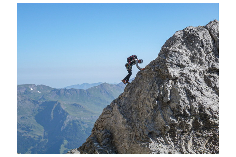
Rifugio Coldai - Via Ferrata Degli Alleghesi a la Civetta (3220m) and descent to Rifugio Torrani (2984m) - Breathtaking views from the Ferrata

Duration : 6h


Day 4 :

Rifugio Torrani (2984m) - Rifugio Coldai (2132m) – Descent to Pala Favera - Rifugio Venezia (1946m) located by the huge block of Pelmo (3168m)

Duration : 5h


Day 5 :

Rifugio Venezia (1946m) - Pelmo (3168m) - Rifugio Venezia (1946m) Recovery stop to then climb the Forcella Val d'Arcia (2476m) and get down to hotel/Rifugio Staulanza (1766m)

Duration : 8h


Day 6 :

Calm stage between alpine meadows, passing by the Rifugio Città di Fiume (1918m) and the Forcella Ambrizzola (2277m), always north on the Alta Vía nº1 to the idyllic Palmieri Hut in Croda da Lago (2046m)

Duration : 4h


Day 7 :

Croda da Lago (2046m) - Río Fuozàrgo (1500m) by Val Negra and Val Forman - View to the south face of the distinctive Tofana de Rozes (3225m) - Rifugio Giussani (2580m)

Duration : 5h


Day 8 :

Refugio Guissani (2580m) -Tofana de Rozes (3225m) - Stunning 360º view - Descent to Cortina d'Ampezzo on our last afternoon in the Dolomites - Well deserved rest at hotel

Duration : 6h


Day 9 :

Breakfast at Cortina d'Ampezzo’s hotel and transfer to Treviso airport.

Included:

  • 8 nights at hotel/hut depending on program
  • AIEGM/AEGM mountain guide services
  • Reservations management service
  • Transfer from Forno di Zoldo to the starting point of the hike and from the Tofana to Cortina d’Ampezzo.


 Not included:

  • Travelling to Forno di Zoldo
  • Transfers from airport to Forno di Zoldo and from Cortina to the airport
  • Any other required transfer in case of unexpected program change
  • Extra snacks and beverages during the stages
  • Single room supplements at hotels
  • Individual required equipment


 General Information:

  • Each group member taking part in the program is required to possess an at date license issued by the Mountaineering Federation or a mountain accident insurance, valid in the Alps.
  • Trekking is an extraordinary pass time but it involves risks. Each member of this journey takes full responsibility of what could happen.
  • The mountain guide reserves the right to modify the program depending on weather conditions, group factor or any other cause that in his opinion may be decisive.
  • Backpack 35-40 l.
  • Backpack rain cover
  • Trekking boots
  • Telescopic poles


  • Light harness
  • 2 screw-lock carabiners
  • Helmet


  • Silk sleeping back


  • Gore-tex jacket
  • Fleece
  • Primaloft
  • Long sleeve thermal shirt
  • T-shirt
  • Trekking pants
  • Medium thickness socks + spare
  • Thin gloves


  • Buff
  • Hat
  • Cap
  • Sunglasses
  • Sun cream factor 50+
  • Lip balm factor 50+


  • Medicines for personal use
  • First aid kit
  • Emergency isothermal blanket


  • Snacks (chocolates, dry nuts,...)
  • Water Bottle 1,5 L


  • Headlight
  • Watch / altimeter
  • Mobile phone
  • ID
  • TSE (European Health Card)


Para que la actividad que te plantes sea un éxito es importante que se adapte a tu nivel, tanto físico como técnico. Aquí te damos unas pautas generales para que puedas hacerte una idea de cual es tu nivel respecto a las salidas que proponemos. De todos modos te recomendamos que te pongas en contacto con nosotros para que podamos asesorarte personalmente o adatar los programas a tus condiciones.


Trekking


    Nivel de TÉCNICO

  • 1 = Debutante. Sin experiencia previa en montaña, tan solo algunas caminatas en terreno llano y sendero bien trazado.
  • 2 = Iniciado. Senderista ocasional, con experiencia en rutas de una jornada. Caminatas en sendero con terreno variado donde podemos encontrar alguna pedrera.
  • 3 = Intermedio. Senderista ocasional, con experiencia en rutas de una jornada o más. Caminatas en terreno variado, donde puede ser necesario atravesar alguna pedrera, un nevero ocasionalmente o una pequeña trepada sencilla.
  • 4= Avanzado. Senderista habitual que realiza caminatas y ascensiones en montaña con regularidad. Experiencia en rutas de varios días. Caminar en terreno accidentado, con presencia de grandes pedreras, fuertes pendientes y ocasionalmente algún nevero. Se precisa buena agilidad en terreno inestable (grava, bloques de roca).
  • 5 = Alto. Senderista habitual que realiza caminatas y ascensiones en montaña cada fin de semana. Experiencia en rutas de varios días con pernocta en refugios o acampada. Caminar en terreno accidentado, que puede contar con presencia de pedreras, fuertes pendientes, neveros y glaciares. Se puede precisar el uso de cuerda.
  • Nivel FÍSICO

  • 1 = Capaz de caminar durante 3 horas con desniveles de subida de hasta 600 metros llevando una mochila ligera de unos 5 kg.
  • 2 = Capaz de caminar en montaña durante 4 a 5 horas y desniveles positivos de 800 metros con una mochila de unos 5 kg.
  • 3 =   Capaz de caminar en montaña durante 5 a 7 horas y desniveles positivos de 1000 metros con una mochila de unos 7 kg.
  • 4= Capaz de caminar en montaña durante 8 horas ascendiendo hasta 1200 metros de desnivel con una mochila de unos 8 kg. Puntualmente en altura > 4000m.
  • 5 = Capaz de caminar en montaña durante 8 horas y desniveles positivos superiores a los 1500 metros con mochila de 10 kg. Puntualmente en altura > 4000m.

Próximas Fechas :

June to September

Descripción:

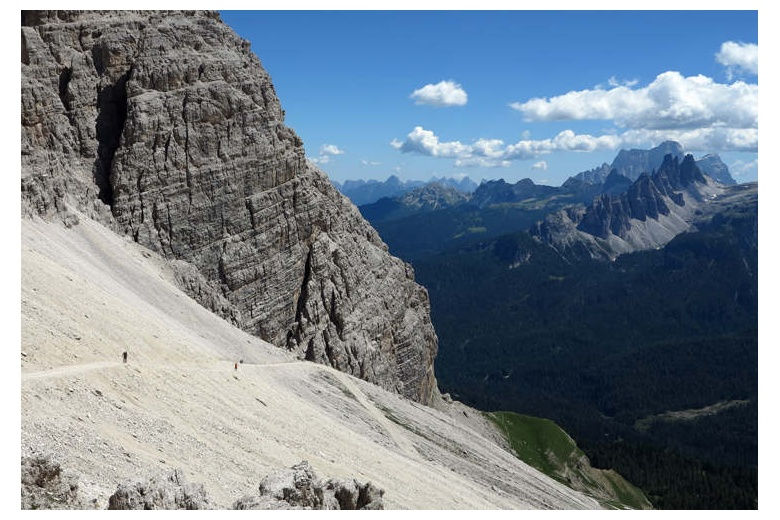
Beauty par excellence. The Dolomites are an extensive mountain range located in the Eastern Alps whose maximum height is the top of the Marmolada (3343m). Its spectacular spires and large walls of more than a thousand meters plus the green and winding valleys make an incredible and superb natural labyrinth worth exploring.

Part of this trekking route follows the Alta Vía nº1, which connects Belluno and Lake Braies throught 150 km of trails.

This program combines calm trekking stages with three climbs to summits over 3000m of altitude in which we will use protection equipment in some of the sections of the ascent.

Niveles :

Físico
4
Técnico
3

los clientes que vieron este programa tambien se interesaron por estos

logo tuc